
Page 12 - Volume 15 Number 8
P. 12
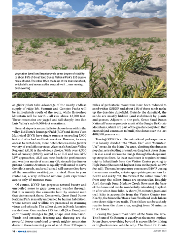
  Vegetation (small and large) provide some degree of stability to about 89% of Great Sand Dunes National Park’s 330 square miles of sand. The other 11% is made up of the main dunefield, which shifts and moves as the winds drive it ... ever moving, ever evolving.
as glider pilots take advantage of the nearly endless supply of ridge lift. Summit and Conejos Peaks will be immediately south of the route, while Horseshoe Mountain will be north – all rise above 13,000 feet. These mountains are jagged and fall sharply into San Luis Valley’s sub-8,000-foot elevations.
Several airports are available to choose from within the valley. Del Norte’s Rominger Field (RCV) and Monte Vista Municipal (MVI) have single runways exceeding 7,000 feet and offer fuel and basic services. However, for easy access to rental cars, more hotel choices and a greater variety of available services, Alamosa’s San Luis Valley Regional (ALS) is the obvious choice. With over 8,500 feet of runway (02/20), served by an ILS and two GPS/ LPV approaches, ALS can meet both the performance and weather needs of most any GA aircraft (turbine or piston). Centric Aviation is equally well suited to serve the pilot’s needs, and a call ahead will ensure they have all the amenities awaiting your arrival. Once in your rental car, a very different national park experience awaits only 45 minutes away.
Of course, MVNP has gorgeous natural beauty and unspoiled acres to gaze upon and wander through. But it is mainly the elements built by ancient man that visitors seek there. Conversely, Great Sand Dunes National Park is mostly untouched by human habitation, where nature and wildlife are presented in stunning vistas and solitude. The tallest dunes in North America reside there. One reaches 755 feet tall (Star Dune) and continuously changes height, shape and dimension. Winds and streams, freezing and thawing are the powerful forces combined to erode mighty mountains down to these towering piles of sand. Over 330 square
10 • KING AIR MAGAZINE
miles of prehistoric mountains have been reduced to sand within GSDNP and about 11% of those sands make up the desolate dunefield. Outside the dunefield, the sands are mostly hidden (and stabilized) by plants and grasses. Adjacent to the park, Great Sand Dunes National Preserve protects much of the Sangre De Cristo Mountains, which are part of the greater ecosystem that created (and continues to build) the dunes over the last 400,000 years or so.
Touring GSDNP is a different national park experience. It is loosely divided into “Main Use” and “Mountain Use” areas. In the Main Use area, climbing the dunes is popular, as is sledding or sandboarding back down them. It is also a real workout to trudge through the deep sand, up steep inclines. At least two hours is required (round trip) to hike/climb from the Visitor Center parking to High Dune (the second-highest dune in the park, at 699 feet tall). The sand temperature can exceed 140o F during the summer months, so take appropriate precautions for health and safety. Yet, the views of the entire dunefield from atop the tallest dunes are spectacular. Roughly April through June, Medano Creek flows past the base of the dunes and can be wonderfully refreshing to splash in after a hot dune hike. A short (30-minute) grassland trail hike is accessible from the Visitor Center too. Nearby, the Montville/Mosca Pass Trailhead leads hikers into three ridge view trails. These hikes can be a shady respite from the dune area, ranging from 30 minutes to 3.5 hours.
Leaving the paved road north of the Main Use area, The Point of No Return is exactly as the name implies. From there, everything beyond is accessible by hiking or high-clearance vehicle only. The Sand Pit Picnic
 AUGUST 2021
